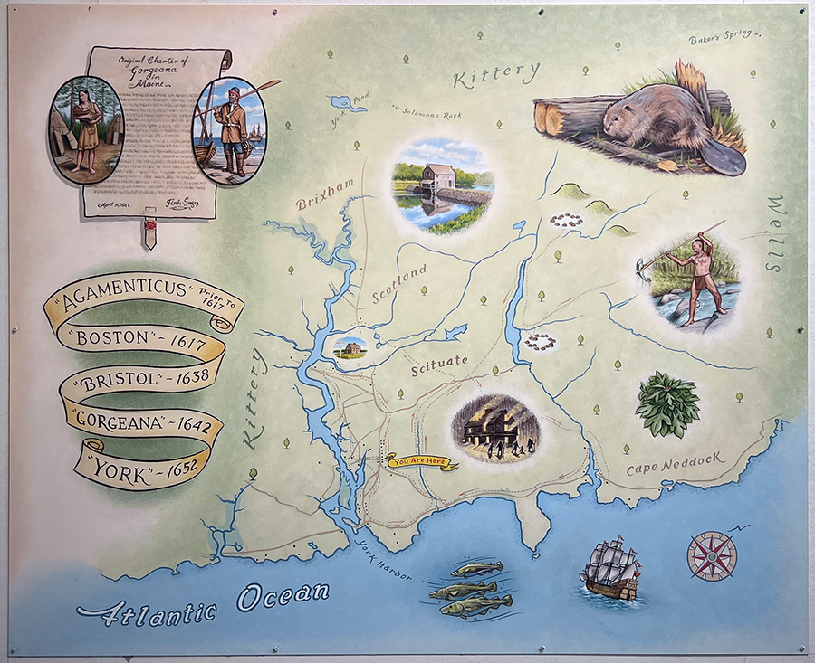
A Note About the Four Maps of York
The land that English colonists would later call York was inhabited by Wabanaki farmers in the early seventeenth century. After newly introduced European diseases devastated the Native population, English settlers under the aegis of Sir Ferdinando Gorges (1568–1647) established permanent inhabitations in the early 1630s. They first called their settlement Agamenticus and then to honor their governor, changed its name to Gorgeana. Sir Ferdinando’s cousin Thomas Gorges (c. 1618–1670) ably governed the Province of Maine from the Gorges manor on Point Christian but in 1643 departed to fight in the English Civil War. After the death of Sir Ferdinando in 1647, the Massachusetts Bay Colony asserted its authority over the town in 1652, changing its name to York.
As the shire town of Massachusetts’s York County, the town remained the center of government for Maine. Peaceful relations between Wabanakis and English colonists ended with the spread of King Philip’s War (1675–78) to Maine in the fall of 1675, and York was subject to many raids during the last quarter of the century. During King William’s War (1688–97) on January 25, 1692, a Wabanaki raiding party destroyed most of the town, killing about fifty colonists and taking more than one hundred captive to Canada. Contributed by Dr. Danny Bottino.
The following timeline is by town of York historian James Kences
1610 April 1614 Capt. John Smith surveyed region—observed Mount Agamenticus
1620 November 3, 1620 Council of New England chartered by Gorges and others.
Autumn 1623 Christopher Leavitt reached Isles of Shoals and explored immediate coast.
1630 Edward Godfrey constructed house at Point Bolleyne.
1631 Edward Johnson arrived—Col. Walter Norton.
December 2, 1631 Twelve Thousand Acre Patent granted to group by Council of New England.
1634 Gorges’s steward Thomas Bradbury erected manor house at Point Christian.
1635 Charter of Council of New England dissolved—Gorges took for himself province of New Somerset from Piscataqua to Kennebec. Godfrey obtained 1500 acres in area of Cape Neddick—transferred part of tract to William Hooke.
June 1640 Thomas Gorges arrived—took up residence at Point Christian. The brief appearance of the Rev. George Burdett.
April 10, 1641 Borough charter of Agamenticus—boundaries set at three miles in all four directions from first meetinghouse. Division of the Twelve Thousand Acres.
March 1, 1642, charter of Gorgeana. Arrival of the ‘Scituate Men’ Preble, Twisden, Bankes, Curtis. The wife of Richard Cornish tried and executed for his murder.
1646 Francis Raynes obtained grant at Brave Boat Harbor. May 24, 1647, death of Sir Ferdinando Gorges.
1650 First reference to John Davis—advocate of Massachusetts takeover.
1651-1652 Edward Godfrey challenged the claim of Massachusetts.
November 22-23, 1652 Massachusetts commissioners ordered submission of government at Gorgeana—December 8, town of York convened first meeting for election of officers.
1655 Thomas Moulton and Henry Sayward took up residence.
1657 Thomas Moulton sold land to Alexander Maxwell a Scotch war prisoner—the beginning of ‘Scotland’ in the western part of town.
1660 At Restoration—the return of Charles II the throne of England—Gorges heirs petitioned for rights.
1661-1662 Formal restoration of the Gorges government.
1663-1664 Royal commissioners sent to New England.
June 23, 1665 Commissioners took possession of province in the name of the King.
1665 The beginning of Rev. Shubael Dummer’s ministry.
1667 Second meetinghouse constructed.
July 1668 Massachusetts commissioners ordered the surrender of government for a second time.
1670 Malcom McIntire, a Scotch prisoner arrived.
1675-1677 The general Indian war in New England.
September 25, 1675, Attack upon James Jackson farmstead at Cape Neddick.
April 1677 Two local attacks documented.
1678 Maine patent sold to Massachusetts by Gorges heirs.
1679-1680 Massachusetts organized government with president and deputy president.
March 1680 Thomas Danforth presented his commission as president—Major John Davis was to serve as deputy. Local petition sent to King Charles II for return of royal government.
1686-1689 Dominion of New England under King James II.
1688-1689 Outbreak of violence with Indians—war between France and England—King William’s War.
1690-1691 Indian attacks documented.
January 25, 1692 The Candlemas Attack—Indian war parties attacked town inflicted casualties and took prisoners for return to Canada.
1694 and 1696 Indian attacks documented.
1696 Capt. John Pickering proposed mills at Mill Creek.
May 1698 Commencement of Rev. Samuel Moody’s ministry.
May 1699 Four roads properly ordered by selectmen.